Chamonix ski map
Brévent and Flégère, Les Grands Montets and Balme, under Mont Blanc. Every run and lift on one map, the numbers, and your own days drawn on it.
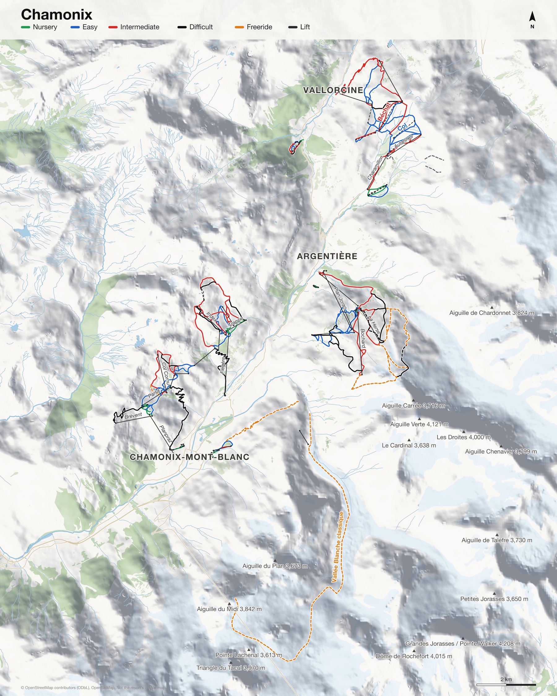
Chamonix at a glance
- Named runs
- 215
- Lifts
- 36
- Runs mapped
- 98 km
- Top of the mapped runs
- 3,233 m (10,607 ft)
- Bottom of the mapped runs
- 1,047 m (3,435 ft)
- Areas
- 3, each its own map
From open map and elevation data, September 2026.
Runs and lifts at Chamonix
104 named runs and 49 named lifts, by grade.
Nursery (16)
- Baby aux Chosalets
- Blatière
- Chosalets
- Forêt aux Chosalets
- Grands Champs
- Grépon
- Les Crys
- Libellules
- Petit Marmotton
- Retour Planpraz
- Retour Planpraz Verte
- Samaran
- Savoy
- Trappe
- Trappe, Libellules
- Verte 2000
Easy (33)
- Accès Flégère
- Alpages
- Arolles
- Arve
- Belle Place Bas, La Louve
- Blanchots
- Chavanne
- Col
- Combe Vioz
- Coqs
- Croix de Lognan
- Esserts Haut
- Evettes
- Évettes
- La Louve
- La Moraine
- Le Col
- Les Posettes
- Liaison
- Liaison Balme
- Liaison Esserts
- Liaison Plan Joran
- Marmottons
- Marmottons, Arolles
- Planards
- Retour Brévent Bleue
- Retour Charamillon
- Retour Flégère
- Sources
- Stade Balme
- Tabe
- Tétras
- Vormaine 3
Intermediate (31)
- Accès TK Floria
- Aiguillette
- Béchat
- Belle Place Bas
- Belle Place Bas, Forêt Verte
- Belle Place Haut
- Bochard
- Bochard Bas
- Bochard Haut
- Caisets
- Charlanon
- Col Cornu
- Combes
- Combes, Blanchots
- Crochues
- Ecuries
- Forêt Verte
- Forêt Verte, Belle Place Bas
- Index
- La Pierre à Ric
- Lachenal
- Les Lycopodes
- Pierre à Ric
- Pylones
- Remuaz Bas
- Remuaz Haut
- Solonges Bas
- Solonges Haut
- Stade de slalom
- Variante Esserts
- Variante Vioz
Difficult (16)
- Béchat Esserts
- Bouquetins
- Chamois
- Charles Bozon
- Floria
- François Bonlieu
- Les Praz
- Nants
- Point de vue
- Point de vue (sometimes groomed)
- Pylônes Bas
- Pylônes Haut
- Remuaz
- skitour: Haute Route Chamonix-Zermatt Grande Lui Variation, skitour: Cabane Argentière Route, skitour: Cabane Trient Route, Col du Passon & Col de Tour Variation, Point de vue
- skitour: Haute Route Chamonix-Zermatt Grande Lui Variation, skitour: Cabane Argentière Route, skitour: Cabane Trient Route, Col du Passon & Col de Tour Variation, Point de vue (sometimes groomed)
- Variante Hotel
Freeride (8)
- Combe des Amethystes, Italian Bowl
- Couloir de Poubelle
- James Bond Track
- La Face
- Pas du Chevre
- Pylônes
- Retour Stade
- Vallée Blanche classique
Lifts (49)
- Aiguillette Button lift
- Altitude 2000 Button lift
- Arve Button lift
- Autannes Chairlift
- Baby Chosalets Button lift
- Bambins Rope tow
- Bochard Gondola
- Brévent Cable car
- Charamillon Gondola
- Charlanon Chairlift
- Chavanne Chairlift
- Chosalets Button lift
- Col Cornu Chairlift
- Col de Balme Button lift
- Évettes Chairlift
- Flégère Gondola
- Floria Button lift
- Index Chairlift
- Jardin d'enfants Magic carpet
- Jardin d'Enfants Button lift
- La Herse Chairlift
- Liaison Brévent - Flégère Cable car
- Marmotton Button lift
- Minivor Button lift
- Parsa Chairlift
- Plan des Reines Button lift
- Plan Joran Gondola
- Planpraz Gondola
- Posettes Button lift
- Poya - Buet Rope tow
- Poya 1 Button lift
- Poya 2 Button lift
- Retour Pendant Chairlift
- Samaran Button lift
- Savoy Magic carpet
- Sources Chairlift
- Tabé Chairlift
- TC Mer de Glace Gondola
- Télécabine de Lognan Gondola
- TK Baby Button lift
- TK Grépon Button lift
- TK Petit Marmottons Drag lift
- TK Vormaine 2 Button lift
- Trappe Chairlift
- TS Planards Chairlift
- TSD Tête de Balme Chairlift
- Vallorcine Gondola
- Vormaine 1 Button lift
- Vormaine 3 Button lift
How Chamonix fits together
Chamonix isn't one ski area but several along the valley under Mont Blanc: Brévent and Flégère on the sunny side, Les Grands Montets above Argentière, and Balme at the head of the valley.
Each is its own map, so a print shows the area you skied, with Mont Blanc and the Aiguilles across the valley named.
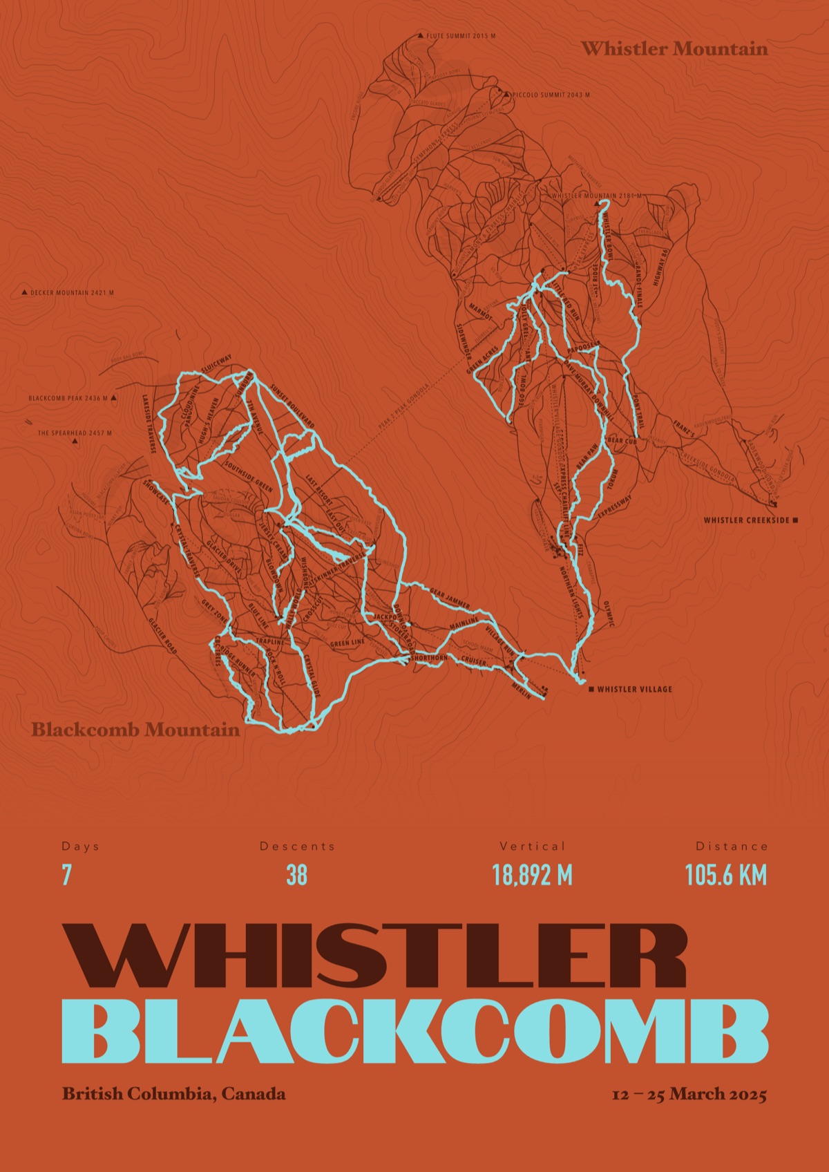
Your Chamonix, run by run
Every run and lift at Chamonix, named, with your own line across it from your phone or watch. One day, one trip or the whole season.
The print shown is Whistler Blackcomb. Yours is drawn from your own days at Chamonix.
£45 unframed Launch price until 31 December
£55 from 1 January · £99 framed
Free delivery to the UK, US, Canada, Australia and New Zealand
For the painted map, see the official Chamonix piste map on the resort's own site.
Good questions
How many runs does Chamonix have?
OpenStreetMap has 215 named runs and 36 lifts at Chamonix. The resort counts its runs its own way, so its number may differ.
How high does Chamonix go?
The highest mapped run starts at about 3,233 m (10,607 ft), and the lowest ends at about 1,047 m (3,435 ft).
Is this the official trail map?
No. Ours is drawn from OpenStreetMap, the open map anyone can edit. For lift status and grooming, use the resort's own map on the day.
Can I get a print of my own days at Chamonix?
Yes. Send the file from Slopes, Strava, a Garmin or any app that exports GPX, and we draw your runs on the whole resort, every run named.
Map data © OpenStreetMap contributors. Custom Map Print is not connected to Chamonix or its operators.
More ski resort maps
- Les Arcs ski mapSavoie, France · 290 named runs · 48 lifts
- La Plagne ski mapSavoie, France · 266 named runs · 74 lifts
- Cervinia ski mapAosta Valley, Italy · 230 named runs · 63 lifts
- Les Trois Vallées ski mapSavoie, France · 377 named runs · 170 lifts
French ski resorts map · All ski resort maps · Ski prints · Snowboard prints
Your runs, on the whole mountain
Send the file from your phone or watch, pick the colours, and we'll take it from there
Make yours