Mammoth trail map
A volcano in the Eastern Sierra, and a long season. Every run and lift on one map, the numbers, and your own days drawn on it.
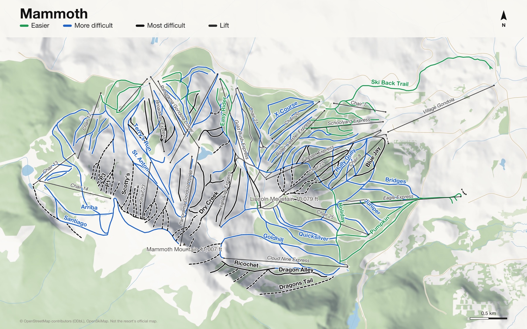
Mammoth at a glance
- Named runs
- 120
- Lifts
- 28
- Runs mapped
- 86 km
- Top of the mapped runs
- 11,024 ft (3,360 m)
- Bottom of the mapped runs
- 8,061 ft (2,457 m)
- Vertical
- 2,963 ft (903 m)
From open map and elevation data, September 2026.
Runs and lifts at Mammoth
159 named runs and 26 named lifts, by grade.
Easier (20)
- Easy Over
- Easy Rider
- Ginger Bread
- Gretel
- Gus Pasture
- Hansel
- Holiday
- Jills Run
- Little Bird
- Lower Road Runner
- Lupin
- Old Comeback Trail
- Pumpkin
- Round About
- Saint Moritz
- Saint Moritz, Mambo
- Sesame Street West
- Ski Back Trail
- Sleepy Hollow
- Spring Canyon
More difficult (67)
- Arriba
- Avalanche
- Back For More
- Big Bird
- Bridges
- Bristlecone
- Broadway
- Center Bowl
- Chickadee
- Christmas Tree
- Clover Leaf
- Comeback Trail
- Commin Through
- Coyote
- Critters
- Crosswalk
- Downhill
- East Bowl
- Follow Me
- Forest Trail Park
- Goldhill
- Gremlin's Gulch
- Havent The Foggiest
- Hully Gully
- Jibs & More
- Juniper
- Knee Deep
- Lodgepole
- Lost In The Woods
- Lower Dry Creek
- Main Park
- Main Park Half Pipe
- Mambo
- Manzanita
- New Critters
- Oops
- Phantoms Escape
- Ponderosa
- Powder Bowl
- Quicksilver
- Ralphie's
- Red Tail
- Redwing
- Repeat
- Ricochet
- Roller Coaster
- Round Robin
- Saddle Bowl
- Santiago
- Secret Spot
- Side Show
- Silver Tip
- Slot
- Solitude
- South Park
- St. Anton
- Stump Alley
- Surprise
- Swell
- Terry's Run
- Training Wheels
- Upper Road Runner
- Wall Street
- Water Tank
- White Bark Ridge
- World Cup
- X-Course
Most difficult (34)
- Agee's Run
- Andy's Double Gold
- Blue Jay
- Blue Ox
- China Bowl
- Christmas Bowl
- Cornice Bowl
- Dave's Glade
- Daves Run
- Dragon Alley
- Drop 18
- Dry Creek
- Encore
- Face of Five
- Fascination
- Glades
- Gravy Chute
- Lower Grizzly
- Lower Shaft
- Lower Viva
- Patrolmens
- Roger's Ridge
- Roger's Right
- Rooster Tail
- Sanctuary
- Scotty's
- Skyline
- Sunset
- Sunshine Glades
- The Acts
- The Wall
- Waterfall
- West Bowl
- White Bark Bowl
Expert (37)
- Avalance Chute 2
- Avalance Chute 3
- Avalanche Chute 1
- Baby Gravy
- Climax
- Dragons Back
- Dragons Tail
- Drop Out Chute 3
- Dropout Chute 1
- Dropout Chute 2
- Grizzly
- Hangman's Hollow
- Head Chutes
- Hemlock Bowl
- Huevos Grande
- Kiwi Flat
- MJB's
- Monument
- P1
- P2
- P3
- P4
- Paranoid Flats
- Philippes
- Santiago Bowl
- Shaft
- Sign Line
- Starr Chute
- The Bear
- The Hump
- Top of the World
- Upper Dry Creek
- Viva
- Wazoo
- Wipeout Chute 1
- Wipeout Chute 2
- Wipeout Chute 3
Ungraded (1)
- Old 10 Breakover
Lifts (26)
- Broadway Express Chairlift
- Canyon Express Chairlift
- Chair 7 Chairlift
- Chair 8 Chairlift
- Chair 12 Chairlift
- Chair 13 Chairlift
- Chair 14 Chairlift
- Chair 20 Chairlift
- Chair 21 Chairlift
- Chair 22 Chairlift
- Chair 23 Chairlift
- Chair 25 Chairlift
- Cloud Nine Express Chairlift
- Discovery Express Chairlift
- Eagle Express Chairlift
- Face Lift Express Chairlift
- Festival Poma Button lift
- Gold Rush Express Chairlift
- High Five Express Chairlift
- Panorama Gondola Lower Gondola
- Panorama Gondola Upper Gondola
- Roller Coaster Express Chairlift
- Schoolyard Express Chairlift
- Stump Alley Express Chairlift
- Unbound Express Chairlift
- Village Gondola Gondola
How Mammoth fits together
Mammoth Mountain is a dormant volcano in California's Eastern Sierra, with a gondola to its summit and runs on every side of it.
Main Lodge, Canyon Lodge and the Village are the three bases. The season here is one of the longest in North America, often running into early summer.
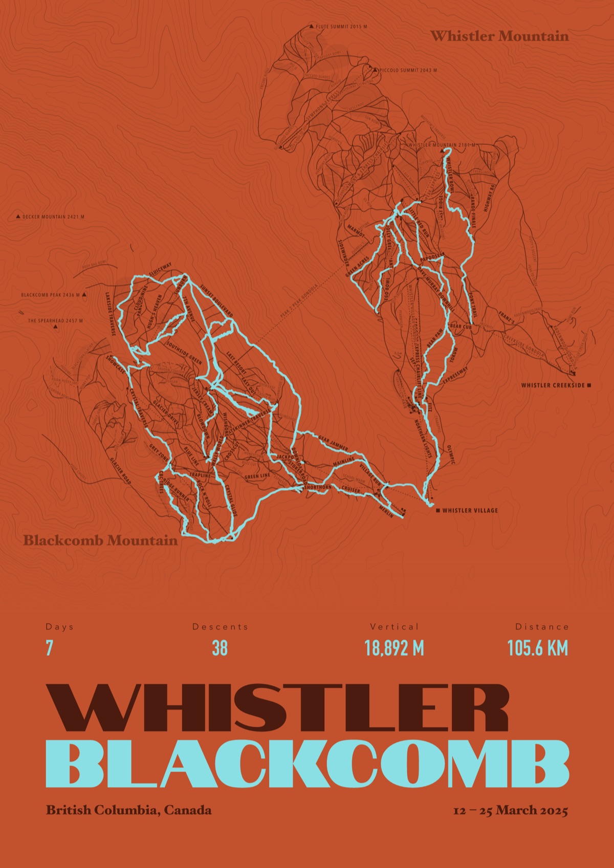
Your Mammoth, run by run
Every run and lift at Mammoth, named, with your own line across it from your phone or watch. One day, one trip or the whole season.
The print shown is Whistler Blackcomb. Yours is drawn from your own days at Mammoth.
£45 unframed Launch price until 31 December
£55 from 1 January · £99 framed
Free delivery to the UK, US, Canada, Australia and New Zealand
For the painted map, see the official Mammoth trail map on the resort's own site.
Good questions
How many runs does Mammoth have?
OpenStreetMap has 120 named runs and 28 lifts at Mammoth. The resort counts its runs its own way, so its number may differ.
How high does Mammoth go?
The highest mapped run starts at about 11,024 ft (3,360 m), and the lowest ends at about 8,061 ft (2,457 m).
Is this the official trail map?
No. Ours is drawn from OpenStreetMap, the open map anyone can edit. For lift status and grooming, use the resort's own map on the day.
Can I get a print of my own days at Mammoth?
Yes. Send the file from Slopes, Strava, a Garmin or any app that exports GPX, and we draw your runs on the whole resort, every run named.
Map data © OpenStreetMap contributors. Custom Map Print is not connected to Mammoth or its operators.
Your runs, on the whole mountain
Send the file from your phone or watch, pick the colours, and we'll take it from there
Make yours