Palisades Tahoe trail map
Olympic Valley and Alpine Meadows, joined by a gondola. Every run and lift on one map, the numbers, and your own days drawn on it.
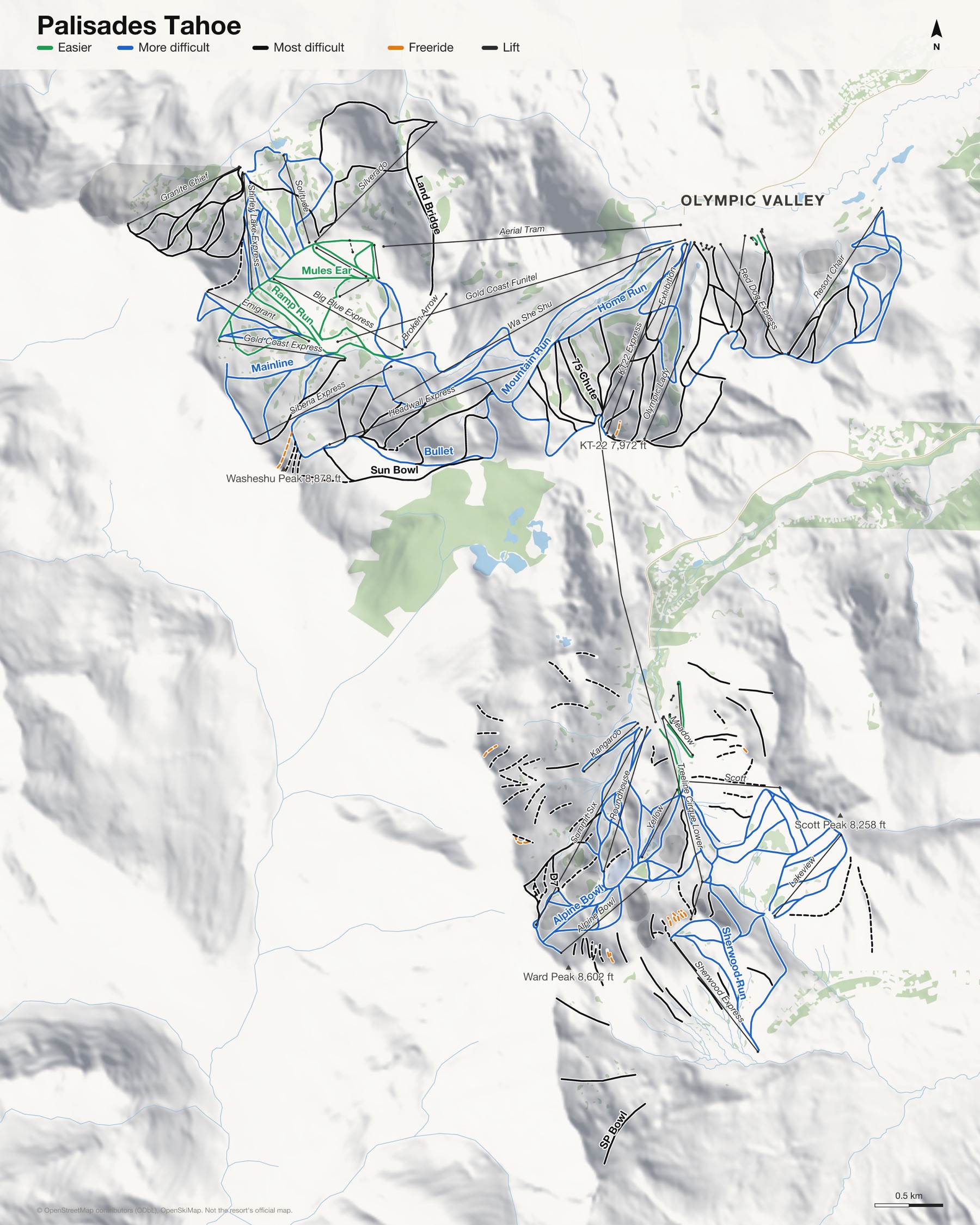
Palisades Tahoe at a glance
- Named runs
- 191
- Lifts
- 44
- Runs mapped
- 105 km
- Top of the mapped runs
- 8,740 ft (2,664 m)
- Bottom of the mapped runs
- 6,201 ft (1,890 m)
- Areas
- 2, each its own map
From open map and elevation data, September 2026.
Runs and lifts at Palisades Tahoe
239 named runs and 44 named lifts, by grade.
Easier (17)
- Bailey's
- Eagle Pass
- Easy Slider
- Gold Coast
- Larkspur
- Lupine
- Meadow
- Monkey Flower
- Mules Ear
- Pioneer
- Poppy
- Ramp Run
- Riviera
- Snow Flower
- Start Me Up
- Subway
- Tiegel
More difficult (88)
- Alpine Bowl
- Aspen
- Atkinson's - 3rd
- Banana Chute
- Barn Road
- Billabong
- Bobby's Run
- Boomerang (Green Trail)
- Bullet
- Champs Elysees
- Charity
- Charity (Red-Green)
- Crystal Palace
- Cut Off
- Dancefloor (Red Trail)
- East Creek
- Easy Street
- Emigrant
- Emigrant Face
- Far East
- Freeway
- Further East
- Gold Coast Face
- Hill's - 2nd
- Home Run
- Howard's Hollow
- Julia's Gold
- Juniper Spire
- Kangaroo Main Run
- Kangaroo Ridge
- Knob Hill
- Ladies' Slalom
- Lake View
- Leisure Lane
- Lone Pine
- Loop Road
- Lower Rock Garden
- Maid Marion
- Mainline
- Marillac's - 5th
- Mixing Bowl
- Monument Ridge
- Mountain Run
- Mountain View
- Mystery
- Newport
- Nick's Run
- North Slope
- Outer Limits
- Packers
- Racers
- Ray's Rut
- Red Ridge
- Reily's Run
- Return Road
- Reuter's 6th
- Robin Hood
- Rock Garden
- Sandy's Corner
- Scott Ridge
- Scotty's Beam
- Sherwood Run
- Shirley Bowl
- Shooting Star
- Siberia Ridge Line
- Skateboard Alley
- Spring Bowl
- Squaw Creek Traverse
- Squealer
- Standard Run
- Standteiner's - 4th
- Summer Road
- Sunnyside
- Sunspot
- Terry's Return
- The Saddle
- Tomlinson's - 1st
- Twilight Zone
- Twin Pine
- Ultraviolet
- Upper Loop Road
- Upper Weasel One
- Valley View
- Weasel Run
- Werner's Schuss
- Winter Road
- Wolverine
- Yellow Trail
Most difficult (80)
- 75 Chute
- Arete
- Ashcroft Gully
- Big Bend Bowl
- Break It Out
- Butcher Block Rock
- CB Chute
- Christmas Tree
- Chute That Seldom Slides
- Controversey
- Cornice Bowl
- Cushman's
- D7
- D8
- Dead Tree
- East Gully
- East Palisades
- Ego Alley
- Expert's Shortcut
- Friar's Tuck
- Gentian Gully
- Granite Alley
- GS Bowl
- Headwall Face
- Heidi's
- High Voltage
- Hogsback
- Horse Trails
- Hot Wheels Gully
- Kangaroo Slope
- Land Bridge
- Lower 40 Face
- Lower 40 Gully
- Lower Champs Elysees
- Lower Cliffs
- Lower Dog Leg
- Lower Saddle
- Magoos
- Main Backside
- Montezuma's Revenge
- Moseley's (aka West Face)
- North Bowl
- Nose
- Oregon Trail
- Outer Outer
- Outer Outer Outer
- Peril Ridge
- Poulsen's Gully
- Powerline
- Promised Land
- Pygmy Forest
- Rainbow Bowl
- Red Dog Face
- Red Dog Glades
- Red Dog Ridge
- Saddle Face
- Schimmelpfennig Bowl
- Secret Garden
- Sherwood Face
- Shirley Access
- Siberia Bowl
- South Face
- SP Bowl
- Strainer
- Strainer Alternate
- Strawberry Fields
- Sun Bowl
- Sympathy Ridge
- Talvert's Ride
- Tamara's
- The Attic
- The Face
- The Slot
- Tiegel Chutes
- Trail 90
- Upper Dog Leg
- West Face Alternates
- West Gully
- West Palisades
- Women's Downhill
Expert (41)
- Beaver Bowl
- Beaver/Estelle Ridge
- Bernie's Bowl
- Big Chute
- Counterweight Gully
- Crag's Gully
- D5
- D6
- Estelle Bowl
- Estelle Gully
- Extra Chute
- Face Cliffs
- Funnel
- Gunner's Knob
- Hidden Knolls
- High Yellow Gully
- Idiot's Delight
- Juniper Face
- Keyhole 1
- Keyhole 2
- Keyhole Open Slopes
- Kitchen Wall
- Light Tower
- Main Chute
- Middle Cirque
- Murhpy's Mistake
- National Chute
- North Cirque
- North Estelle
- Our Father
- Peter's Peril
- Piston Bulley Slope
- Poma Rocks
- Pond Slope
- Ridge Nose
- South Beaver
- Subway Cliffs
- The Buttress
- Three Sisters
- Upper Cliffs
- Waterfall
Freeride (13)
- Chimney
- Clear Gully
- Clear Gully Open Slope
- Dogleg
- Fingers
- Marenka
- McConkey's
- NC
- Scott Chute
- Snags
- The Castle
- Treeline Cirque Left
- Treeline Cirque Right
Lifts (44)
- Aerial Tram Cable car
- Alpine Bowl Chairlift
- Bailey's Beach Chairlift
- Base to Base Gondola
- Belmont Chairlift
- Big Blue Express Chairlift
- Boone Magic carpet
- Broken Arrow Chairlift
- Emigrant Chairlift
- Exhibition Chairlift
- Far East Express Chairlift
- First Venture Chairlift
- Gold Coast Express Chairlift
- Gold Coast Funitel Gondola
- Granite Chief Chairlift
- Headwall Express Chairlift
- High Camp Carpet Magic carpet
- Kangaroo Chairlift
- KT22 Express Chairlift
- Lakeview Chairlift
- Meadow Chairlift
- Mountain Meadow Chairlift
- Murphy Magic carpet
- Olympic Lady Chairlift
- Red Dog Express Chairlift
- Resort Chair Chairlift
- Roundhouse Chairlift
- Scott Chairlift
- Sherwood Express Chairlift
- Shirley Lake Express Chairlift
- Siberia Express Chairlift
- Silverado Chairlift
- Snow Venture Carpet Magic carpet
- Solitude Chairlift
- Subway Chairlift
- Summit Six Chairlift
- Sun Daddy Magic carpet
- Sun Kid Magic carpet
- Treeline Cirque Lower Chairlift
- Treeline Cirque Upper Chairlift
- Tucker Magic carpet
- Wa She Shu Chairlift
- Wylee Magic carpet
- Yellow Chairlift
How Palisades Tahoe fits together
Palisades Tahoe is two mountains next to each other above Lake Tahoe: Olympic Valley, home of the 1960 Winter Olympics, and Alpine Meadows. A gondola now links the two bases.
Olympic Valley is known for its steep lines off KT-22 and the Palisades, Alpine Meadows for being the quieter, more local of the two.
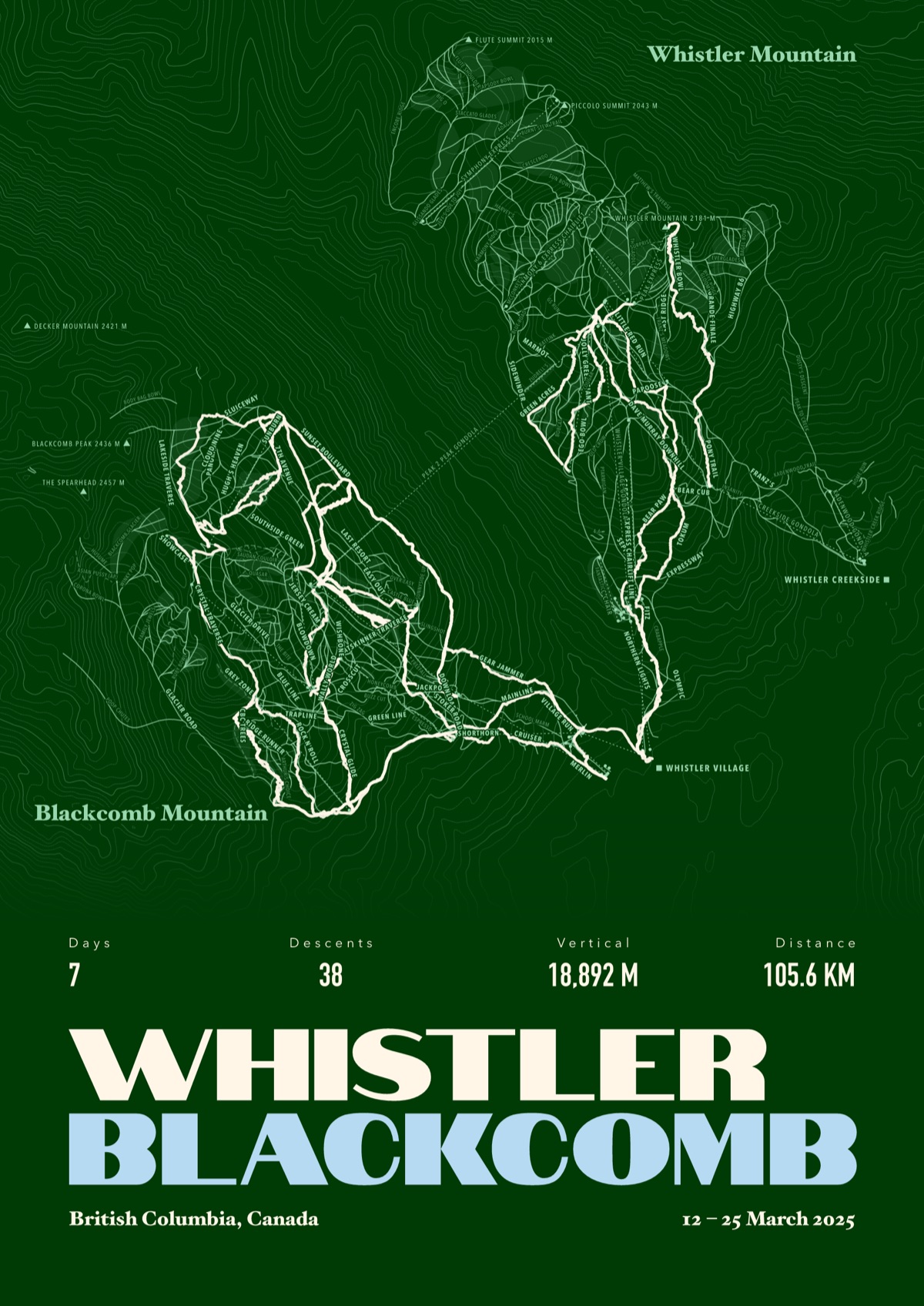
Your Palisades Tahoe, run by run
Every run and lift at Palisades Tahoe, named, with your own line across it from your phone or watch. One day, one trip or the whole season.
The print shown is Whistler Blackcomb. Yours is drawn from your own days at Palisades Tahoe.
£45 unframed Launch price until 31 December
£55 from 1 January · £99 framed
Free delivery to the UK, US, Canada, Australia and New Zealand
For the painted map, see the official Palisades Tahoe trail map on the resort's own site.
Good questions
How many runs does Palisades Tahoe have?
OpenStreetMap has 191 named runs and 44 lifts at Palisades Tahoe. The resort counts its runs its own way, so its number may differ.
How high does Palisades Tahoe go?
The highest mapped run starts at about 8,740 ft (2,664 m), and the lowest ends at about 6,201 ft (1,890 m).
Is this the official trail map?
No. Ours is drawn from OpenStreetMap, the open map anyone can edit. For lift status and grooming, use the resort's own map on the day.
Can I get a print of my own days at Palisades Tahoe?
Yes. Send the file from Slopes, Strava, a Garmin or any app that exports GPX, and we draw your runs on the whole resort, every run named.
Map data © OpenStreetMap contributors. Custom Map Print is not connected to Palisades Tahoe or its operators.
Your runs, on the whole mountain
Send the file from your phone or watch, pick the colours, and we'll take it from there
Make yours